JOHN S. ALLEN'S BICYCLE FACILITIES, LAWS AND PROGRAMS PAGES

trakbi2s.gif (1391 bytes) Top: Home Page
Up: Minneapolis
Previous: evaluation
Next: Alec Kloss's comments

Contact John S. Allen

trakbils.gif (1395 bytes)

Review of the
Hennepin County
Bicycle Transportation Plan

John S. Allen

First, some background information, for reference:

Links to official documents

Hennepin County bicycle page, including links to the Hennepin County Bicycle System Plan.

  • Maps: Note that the blue routes are labeled as "bikeways on/off roadway" -- so it is not possible to determine whether they are one, the other, or both. But as the red lines indicate "independent corridor trails", the off-roadway sections pretty much have to be sidepaths.

  • Executive Summary, adopted 1996, reprint 2, September, 2001. Confirms that sidepaths are a major part of the plan. More details are in the review that follows.

City of Minneapolis bicycle page, including links to the following:

  • Minneapolis Bicycle Plan map -- shows the existing facilities and other planned ones.

  • City of Minneapolis information on rules of the road -- generally good advice, but does not describe situations specific to Minneapolis -- in particular, what rules of the road might apply to center-of-the-road bike lanes.

  • City of Minneapolis information  on how to avoid bicycle crashes -- includes advice to stay outside the door zone, though the City has constructed bike lanes in the door zone. Includes good advice on using lights at night and on riding through conventional intersections -- but no advice on how to ride in a bike lane in the middle of the street.

  • Bikeway plan map, downtown section

General criticisms

The following are my major criticisms, based on my reading of the Executive Summary. I note that only the Executive Summary is online, not the full report. However, a proper Executive Summary should cover all of the important points in a report. I am assuming that this one does.

If that assumption si correct, it is my opinion that the Hennepin County Bicycle Plan is seriously deficient and unbalanced in its emphasis.

  • The plan is only a bicycle route plan and a description of geometrics for various types of bikeways.. It does not live up to its name as a bicycle transportation plan. The four E's -- Engineering, Education, Enforcement and Encouragement -- have been well-known for decades as essential to an effective and balanced bicycle program.  The plan only describes engineering measures.

  • The plan concerns itself mostly with developing a system of through bicycle routes that cover distances over which cycling is very rarely used for transportation (see map). Creating through routes suitable for novice cyclists, as this plan appears to try to do, is not an effective transportation strategy. Novice cyclists generally do not use their bicycles for transportation over long distances.

  • Neighborhood connectivity -- the ability to get directly to nearby destinations -- is far more of an issue for bicycle transportation than are long-distance routes. There is no mention of the issue of connectivity. This issue is a very serious concern  in suburbs, where sprawled cul-de-sac residential and business development often requires long, circuitous routes on arterial streets to cover short distances. A Web page on this site discusses the issue of connectivity in more detail.

  • The plan creates the impression that cyclists need special bicycle facilities the way trains need tracks. But, except in urban areas, the designated routes are spaced so widely that they can not serve most trip generators.  There is no discussion of bicycle travel or facilities improvements anywhere else than on the designated routes.

  • The plan describes sidepaths as "on a par" with "bicycle-compatible roadways". Research has repeatedly shown sidepaths to be hazardous. They also delay cyclists because of the need to yield to traffic in cross streets, even when traveling on an arterial. AASHTO bicycle facility guidelines strongly discourage sidepaths.

  • "Bicycle compatible roadways" are described as only those which are specially designated for bicycle use. While designated roadways may receive special treatment and that may improve them, these are only a small minority of roadways which are attractive and safe for bicycle use.

  • There is no mention whatever of the effect of traffic volume on the suitability of a roadway for bicycle use. This is an especially important omission because local and collector streets, which account for the great majority of street mileage, serve cyclists well due to their low traffic volume. Rural roads that carry little traffic also do not need improvement, and are favorites with cyclists for recreational riding.

  • There is no evaluation of existing facilities and programs to identify problems which need to be remedied. A particularly stunning omission is the absence of any discussion of the very unusual and nonstandard middle-of-the-street bicycle lanes in Minneapolis, or of the issues contingent on the high volume of bicycle traffic in and around the University of Minnesota campus.

  • There is no mention of bicycle parking, or bikes on transit, or any other useful amenities for cyclists.

  • There is no review of data on bicycle use and bicycle crashes. Such a review would be necessary to identify priorities and to develop a cost-effective program for crash reduction.

  • All in all, the report shows very little evidence of awareness of the body of work in safety research, engineering or bicycle program design which underlie better programs elsewhere.

Review of the Executive Summary

The preceding discusses mostly  what is omitted from the Executive Summary. The following paragraphs discuss what is included in it.

To its credit, the plan indicates that the County supports bicycle use and descrribes the role of the county in planning for bicycling, previously regarded as a local concern: "Hennepin County believes that there is a critical need to establish a safe, convenient bicycle transportation system." (p. iv). "It is envisioned that an extensive countywide bikeway system will be designed to serve all types of bicyclists regardless of their levels of rider expertise or travel destination." (p. 5)

But then the report qualifies this statement:

Although the goal of the plan is to provide full accommodation to all types of bicyclists, existing conditions and constraints may require different levels of accommodation from one corridor to the next. Five levels of accommodation (not necessarily listed in order of importance) were developed for Hennepin County road right-of-ways:

  • Full Accommodation

  • Independent Trail

  • Bicycle Compatible Roadway

  • Multi-Use Path

  • Basic Roadway

It is sloppy and misleading to speak of different types of accommodation as "levels." There is no intrinsic hierarchy among them. If, as the report almost immediately indicates, these are "not necessarily in order of importance", then why call them "levels" at all?

Now, let's examine the Executive Summary's description of the five "levels": this description occupies almost the entire remainder of the Executive Summary.


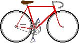
"Full accommodation" -- two-way sidepath
plus street with bike lanes.

fullaccom.jpg (40322 bytes)


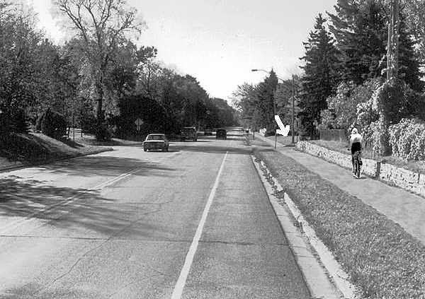
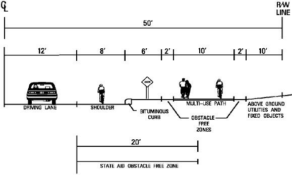
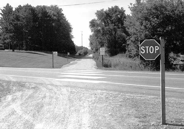
"Full accommodation" (page 6) is defined as a roadway with bicycle lanes, plus a sidepath. The photo illustrating this arrangement, which is described as "ideal" (top level, that is, despite the disclaimer about levels), shows a lightly traveled road with bike lanes, and a sidepath adjacent to a stone wall -- clearly a two-way sidepath, as there in none on the other side. "Wrong-way" travel on a sidepath is highly hazardous, because drivers crossing the sidepath are looking in the opposite direction for traffic.

I have sharpened the photo from the Plan, revealing that the cyclist -- the only cyclist who appears in any of the photos illustrating the five types of accommodation --  has been added using photo editing. It's no wonder that the cyclist had to be faked -- a cyclist of the sort who wears special cycling clothes would be unlikely to ride on a sidepath which he or she would know to be highly hazardous at normal bicycle travel speeds.

In the background (see arrow), is a driveway or cross street where the approach of a cyclist would be concealed by the stone wall and by vegetation, increasing the hazard.

With the wall adjacent to the sidepath, the example given in the photo does not even conform to the cross-section diagram which is included in the Executive summary. (This is one of many  geometric diagrams in the Executive Summary online. The others describe the other "levels".).


fullac.gif (6025 bytes)


The quandary of "full accommodation" is that a sidepath attracts novice cyclists without assuring their safety. The roadway accommodation shown in the pictures, without the sidepath, would be entirely appropriate to any child a parent would allow out of sight on a bicycle.


"Independent trail"

trail.jpg (32940 bytes)


"Independent trail" (page 7) is described as the usual multi-use trail on an abandoned rail right-of-way or other right-of-way where there is not a road. The Plan states:

"The physical separation from traffic offered by trails is reassuring to casual adult and children bicyclists. They are also popular with some advanced commuter riders at those times during the day when the facility is not crowded with slower bicycle users, pedestrians or other users."

Trails are popular, and can not be judged only on their merits for bicycling, as they serve other constituencies besides cyclists. The quoted statement acknowledges that trails are not safe for travel at full bicycle speed when crowded with other users. However, the report does state that "the independent trails form a part of the primary bicycle system due to their incorporation of limited vehicle crossings and grade separations."

This is a problematic statement because it implies that other routes might be disregarded if a trail is constructed. An alternate, parallel route might be needed when

  • the trail is crowded

  • it does not serve a trip generator, which is more usually along a road

  • it is not usable due to snow and/or ice in winter

Also note in the photo above that the trail is unpaved, raising issues of the durability of the surface and making pavement markings impossible; there are wide tire marks on the trail, suggesting that it is serving motor vehicles; and the far side of the crossing is concealed from motor traffic by vegetation. This trail might be useful for bicycling but it is by no means an optimum example.


"Bicycle compatible roadway"

compatible.jpg (42182 bytes)


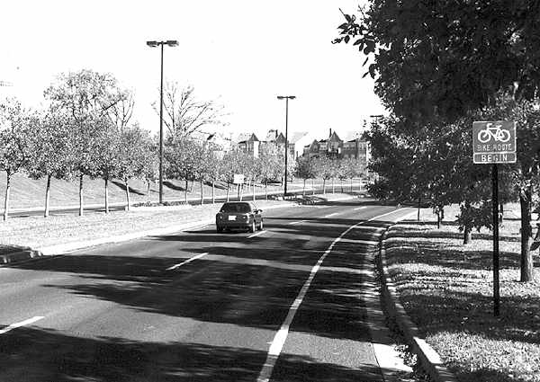
"Bicycle compatible roadways" (page 9) are described as

a configuration of on-road space designated for multiple purposes including bicycles. Other uses such as temporary parking for disabled vehicles are typically allowed. In some urban situations such as in downtown Minneapolis and near the University of Minnesota, the roadway space is actually designated for bicycles-only by appropriate signage (bike lane) and pavement markings. Bicycle compatible roadways can be delineated with a painted stripe, colored or textured pavement, or an extended concrete gutter section.

Bicycle compatible roadways are excellent facilities for avid bicyclists and some casual adult riders (depending on traffic conditions). Many Hennepin County roadways are designated or could be designated as bicycle compatible roadways since they have sufficient existing shoulder width areas.

The statement is implicitly made here that a roadway must be designated in order to be suitable for bicycle use, when in fact, bicycles are permitted on all but limited-access roadways, and there are many roadways, especially in residential and rural areas, which serve even novice and child cyclists well just as they are.

There is no discussion whatever of the design issues and problems which can occur with special bicycle facilities on the roadway. The example from the Plan, shown in the photo above, is a very nearly ideal one; a parkway with no cross traffic. Still, it appears that the area to the right of the solid stripe is not a bike lane, as there are no bike lane symbols or markings. It is then possible that this area would be used lawfully for parking during times of heavy use of the park through which it passes. In that case, the roadway would still be suitable for use by competent cyclists, but it would not attract children or novices.

"Multi-use paths" are described as

a level of accommodation on par with the bicycle compatible roadways. They provide a parallel path to the roadway usually within the roadway right-of-way. The path is generally separated from the adjacent roadway. Multi-use means that pedestrians and in-line skaters are also allowed on the facilities.


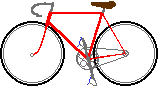
"Multi-use path" -- actually a sidepath.

mup.jpg (47378 bytes)


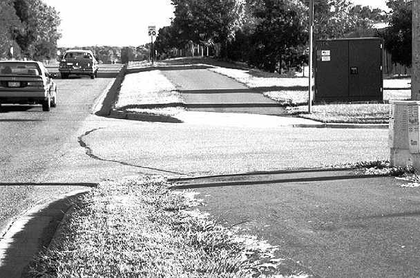
Aside from the distressingly poor design elements, just what is intended by the statement that sidepaths are "on a par with the bicycle-compatible roadways"? This statement is meaningless, because the two types of facility are so different.

The words "multi-use path" are generally used to describe what this report calls an "independent trail." What the photo shows is in fact a two-way sidepath. It has obstacles -- signposts and an electrical junction box -- too close to its edge to meet standard engineering guidelines. Also, there is a large sight obstruction for drivers who are about to cross the path to enter the roadway. These elements do not conform to the geometric diagram in the Executive Summary.

The roadway in the photo appears to have ample width for bicycle/motor vehicle lane sharing. The speed limit of 50 mph,  typical of rural areas, does correspond to a higher likelihood of overtaking collisions than occurs with lower speed limits, though such a high speed limit is unusual for a roadway with curbs and driveway entrances.

The temptation to construct sidepaths is strong, because they can also serve as sidewalks, and because many people believe that cycling on sidewalks is safe. But these people are wrong.

Being adjacent to roadways, sidepaths do not provide a quiet, scenic recreational experience. They reach more trip generators than typical trails, but they are just as unsuitable for winter use by cyclists, and for use by fast cyclists when crowded.

But sidepaths -- unless they can be placed far from the roadway and are not crossed by driveways or streets -- have serious hazards that "independent trails" do not have:

  • even low-beam headlamps are aimed toward the cyclists who are riding toward the road traffic in the nearest lane;

  • conflicts at driveways at intersections are very serious.

Sidepaths are the preferred choice only in a few special circumstances. Widening the road (but adding a narrower sidewalk for pedestrians) and possibly lowering the speed limit, or a trail away from the roadway, all would be preferable in the situation shown.

Sidepaths are also seen by cycling advocates as a threat to their right to ride on the roads. Minnesota does not have a mandatory sidepath rule, but  harassment of cyclists for riding on the roadway is common where sidepaths exist.


"Basic accommodation"

basic.jpg (26535 bytes)


"Basic Roadway accommodations" are described as follows:

...due to design and/or right-of-way constraints, bicycles must share road space with motorized traffic. Under this situation, the county routinely removes obstacles and hazards to bicycle travel along the roadway edge. In some cases where adjacent sidewalks and occasional bicycle usage exists, a widened lane may be provided to provide refuge space and vehicle reaction distance. Bicycle usage on basic roadways is not encouraged nor is bicycle route signage included on these types of roads. Basic roadways are the lowest desirable level of accommodation, and they do not meet the standards necessary for inclusion into the primary or secondary county bicycle systems. Many existing urban and rural roadways are currently basic roadways with little special provision for bicycles.

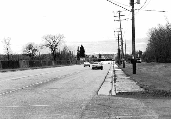
This is an extraordinary statement, because in fact, the great majority of roadways in the project area would have no special provision for cyclists, even if the entire plan is completed. Furthermore, the clear indication that a wide outside lane is an undesirable accommodation for cyclists (and that the roadway is not "bicycle-compatible") is without any basis in scientific fact, and runs counter to the experience of cyclists over several decades.

And once again, a "level" statement is made, despite the earlier disclaimer.

The photo illustrating "basic roadway accommodations", unlike any of the others, shows a location which is poorly maintained and esthetically unattractive. It is on an arterial street -- though in fact, the great majority of the street mileage which is not designated as a bicycle route is on local and collector streets that carry only light traffic. The photo also shows a road defect that could just as easily occur anywhere else: a wide gutter pan with an uneven seam such that cyclists would have to ride well to its left or else risk a diversion-type fall. If this problem were remedied, the width of the outside lane would be more than ample for bicycle-motor vehicle lane sharing.

Conclusion

This report fails to address three of the four major elements of a bicycle program, and is very troubling in the way it addresses the remaining one.

Thanks to Sarah Etter for drawing my attention to this report.


Top: Home Page
Up: Minneapolis
Previous: evaluation
Next: Alec Kloss's comments

Contact John S. Allen

Contents © 2003, John S. Allen
except for images, public domain.
Last modified 16 July 2003