[Top] John S. Allen's home page
[Up] Alexander M. Stewart
[Previous] Map home page
[Next] Detailed instructions


A Map of the Seneca Villages and the Jesuit and French Contacts 1615-1708
(version with white background)


Table of Contents

Instructions for viewing
A Guide to the Map
Description of map
Chronology:
1608 1615 | 1642 | 1646 | 1649-50 |
1656 | 1666 | 1668 | 1677 | 1678-79 |
1683-84 | 1700 | 1759
Conclusion
Reference works
Footnotes
Large map
Detailed instructions
How this map came to be


Reading the Guide to the Map and viewing the map


Click in the small keymap below or on links in the text of the Guide to the Map to view the corresponding part of the full-scale map. Your browser may take you only to the target row; then scroll to the right using the keyboard or mouse. Click here for more complete instructions, especially if display of the map when scrolling is very slow. The maps for this page have a white background. You may also view an alternate version of this page that has maps with colored background panels as a navigation aid.


  A B C D  
1 Click on this map to go to the same part of the large map 1
2 2
3 3
4 4
5 5
6 6
7 7
  A B C D  


***

A Guide to the Map of the Seneca Villages and the Jesuit and French Contacts 1615-1708

Revised
by Alexander M. Stewart
Map drawn by Helen M. Erickson
Published by the Author
30 Audubon Street, Rochester, New York
Third Edition, May 1955
Transcribed and edited by John S. Allen, March 1997


Note: links in red like 1A:2B are to map panels. Detailed instructions.

Begin by placing the map in plain view, then observe the name of the map, in the lower center 6B:7C, and the dates 1615, soon after the first white contact in 1611, and 1708, the time of the retreat of Father De Heu. Above the lower center, 5A:6D, notice five Indian villages and remember that the powerful and warlike Seneca tribe resided in these villages. The watercourses and modern villages are from the United States Geological Survey maps. The area of the map is about twenty by thirty miles. The villages have Indian names, the name of the Christian chapel and the name of the nearby modern American village.


Locations: Three villages are south from Rochester, N. Y., near Clover Street. Totiakton No. 1, or Sonnontuan, 5B, is on the hill south of the station at Rochester Junction, Lehigh Valley Railroad. Totiakton No. 2, 6B, is on the Dann farm, one mile west of Honeoye Falls, to the right of the turn to Lima. (See monument.) Various museums received a large collection of Seneca and Jesuit relics which had been unearthed on this site. Two villages are south of Victor. From Victor to Ganagaro, 6C, and the monument is one mile on the Victor-Holcomb Road.


Three miles father on, in the village of Holcomb, just before crossing the railroad, turn left between a cider mill and lumber yard. Then go two miles and cross one new concrete bridge, stop immediately and look up on the left for the boulder monument illustrated on the lower right of the map. Gandougarae, or St. Michael's, 6D, was one-half mile downstream from the monument. The place is known as the Marsh or Buell farm. Nothing remains on these beautiful hill-top sites, but letters written from these places and translated into English [1] are in libraries. Museums in Rochester, Buffalo and Albany contain fine reproductions of Seneca cabins and remains of Seneca village life. The sites are on private property; the owners appreciate being asked. Much of the work of rediscovering these sites was done by William Beauchamp of Baldwinsville, N.Y., and General John S. Clark of Auburn, New York.


These villages were reached, during the French colonial period, almost entirely via Québec. Travel was via the St. Lawrence River around the eight big rapids, wading in shallow water, then into Lake Ontario, to the Oswego River, to Jesuit headquarters on Onondaga Lake (upper right inset, 3D). The way then was by the Seneca River as far as a canoe could go, then by the Great Middle Trail to the Seneca country. All incoming Jesuits reported to the Superior at Onondaga. Father Frémin walked from Lake Champlain.


See date 1608 (upper right inset, 1D:2D). Champlain founded Québec and soon after, in 1615, began the alliance with the Hurons and Algonquins, enemies of the conquering Iroquois, which began the policy of alliance with other enemies of the Iroquois.


1615 (lower right, 7D), Stephen Brulé and other young men were employed by Champlain to help explore the country. It was a time of hard travel, at an average rate of 30 miles a day, by canoe and carry. Thousand mile journeys were frequent. Brulé and Champlain reached the Hurons by the Ottawa River, passing 240 miles north of Toronto, through Lake Nipissing and the French River to Georgian Bay, the great eastern bulb of Lake Huron (not on this map; see map of Ontario), and came to the Huron villages, a four to six weeks' trip. The Huron villages were on or near Lake Huron, 70 to 100 miles north-northwest of Toronto. Brulé, sent by Champlain, crossed New York to the Susquehanna River and return. Champlain and missionaries and their helpers went with Brulé into the Huron country. (Tourists, see shrine near Midland, Ontario and a magnificent monument to Champlain in Orillia, Ontario). Many Hurons became Christians. From the Huron country Fathers de la Roche Daillon [2] (1626) and Jean de Brébeuf and Joseph Chaumonot (1640) came southward into New York State, near Lockport.


1642 (upper right inset, 3D), Father Isaac Jogues and René Goupil, with many canoes loaded with supplies, returning to the Huron country from Québec, were captured by the Mohawks.[3] Goupil was tomahawked. Fr. Jogues was held a slave, and he used his slavery as an opportunity for missionary work.

1646 (upper right inset, 3D), Father Jogues on a third trip to the Mohawks and John Laland with him, were killed. (Visit shrine at Auriesville, N.Y.)

1649-50, the Senecas and their allies (see upper right center inset, 2C:3C) destroyed the Huron nation, killed five French missionaries who were canonized in 1930, and adopted a village of Christian Captives. (See Holcomb).


1656 (see on map first chapel at Onondaga, second chapel at Cayuga, 3D, Chaumonot in list of missionaries 4A:4B and Holcomb monument). Huron Christian captives among the Iroquois tribes demanded missionaries. The Iroquois made peace with the French. Only the Mohawks remained hostile. A French colony was started beside Onondaga Lake, at the present site of the French fort on the Onondaga Parkway. From here missionaries went to all the Iroquois tribes.


A plot to massacre all the French members of the new colony was discovered. The missionaries were recalled to Onondaga, called then Ganentaa. A great feast was given in which the Indians were compelled, by a solemn custom, to eat everything placed before them. When the Indians crawled, half paralyzed, to their cabins, more than fifty Frenchmen, terrified at every sound, stole down the Oswego to Lake Ontario and, without guides, ran the rapids of the St. Lawrence, losing only two men. War ensued in which Father Peter Raffeix (middle left inset, 4A:4B) was chaplain of the Tracy and Courcelles expedition[4] in which 1200 men marched from Montreal to Schenectady on snowshoes, in January, in temperature more than 30 below zero, using only such camping equipment as they could carry. They reached an Indian village[5] near Schenectady and the Mohawks made peace.


1666 (upper right inset, 3D), Albany and New York had been English for two years without these Frenchmen knowing it. George Downing[6], Harvard class of 1642, was the agent for the English Crown who in 1664 influenced the Dutch to adopt Dutch Guiana for their holdings in New York. (Remember George Downing, godfather of Downing Street in London, England.) An unbroken strip of English territory from Maine to Georgia was formed by this deal. All this strip was near to ocean-going commerce with cargoes of a hundred tons possible and with all the year-round traffic, which contrasts with the far-flung French territory with the canoe cargo limit under three tons and with the one Québec harbor for ocean traffic usually closed through a long winter.


1668 (inset middle left, 4A:4B and Father Frémin's village, 5B). Missions were resumed in all the Iroquois cantons. The Iroquois thereby took advantage of 16 years' peace by trying to capture the fur trade[7] of the Illinois and Upper Lakes Indians. In the left middle inset, 4A:4B, are the names of the missionaries and the dates of their residence in this territory. Chaumonot made only a visit. Father Frémin and his assistant were the first white residents of Monroe County. By 1673, with the coming of Father Pierron, each of four villages had its bark chapel. Father Garnier was resident in this region for 16 years, with no record of his going away until 1683 (see sailing vessel, upper right, 1D).


The high quality of these men deserves recognition. Their intellectual training and spiritual endowments would be equal to those of the teachers in theological seminaries. Any one of them could take a Ph.D. degree. They knew French, Greek, Latin, Hebrew, and several Indian dialects. Individual talents were given training (see Fr. Pierron, lower right). Father Garnier, in his later years, made a report of the habits and customs of the Seneca Indians through Father Lafitau, who wrote a large two-volume work on American Indians, comparing their customs with the habits of classical and Oriental tribes. Overloaded with learning, this book shows, nevertheless, the best erudition of the great universities of that day.


One of the earliest maps of this region was made by René Galinée, followed by a map by Father Raffeix. All the Great Lakes were carefully mapped by missionaries of this period. In addition to cartography they also knew campcraft and forest lore. On journeys they used their long robes for tents. A member of the Company of Jesus might one year be confessor to a European princess and next year be Shepherd of Souls among cannibals. He was equal to both duties. High as was their learning, they gave themselves up utterly to the ideals of Divinity and eternity, using a daily military discipline of the spirit to achieve these ends. Father Morain's affliction (upper right, 1C) may have been caused by kneeling two hours daily on cold ground or possibly by kneeling in a canoe or wading up rapids. Their valiant faith stands out with interesting contrast in a time that is conceited about its uncertainty. By their lives they furnished their own scientific proof of what they believed.


Their days were long, beginning before sunrise with personal religious exercises, followed by such a day of visiting Indians as would tire out a modern salesman. They made unremitting effort to go the rounds of the more than 4000 members of their parish as frequently as possible. They were sad only when some soul which they might have sent to glory escaped their ministrations. Their baptisms and their prayers were considered sorceries by the Indians, so that they were constantly in danger of death -- a danger which they met with sublime patience and unfailing tact. We need the memory of them to leaven our modern view of life.


1677 (middle right inset 5D and quaint English quotations 4D). Wentworth Greenhalg[8] is the only prominent English-speaking contact during this period. He reported the military strength of the Indian tribes. This was the earliest English interest in Seneca territory.

Fort Frontenac, on site of Kingston, Ontario (upper right inset, 3C), was the French base of control for Lake Ontario. Here in the summer of 1678 the first sailing vessels on Lake Ontario were built. From here La Salle made several visits to the Iroquois tribes. His first visit was in 1669 (see canoes on lake, 1B), when he spent four weeks at father Frémin's village, Sonnontuan, 5B, waiting for a captive Wisconsin Indian to show him the portages to the Mississippi from the Upper Lakes. When the Senecas returned from trading with plenty of Dutch liquor, they got drunk and burned the captive Indian.


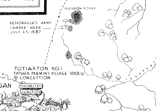
1678-9 (upper left inset, U.S. 20, 2B -- 
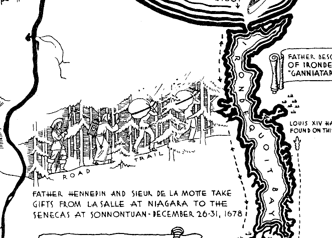
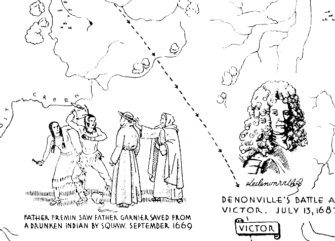
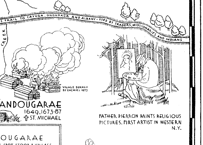
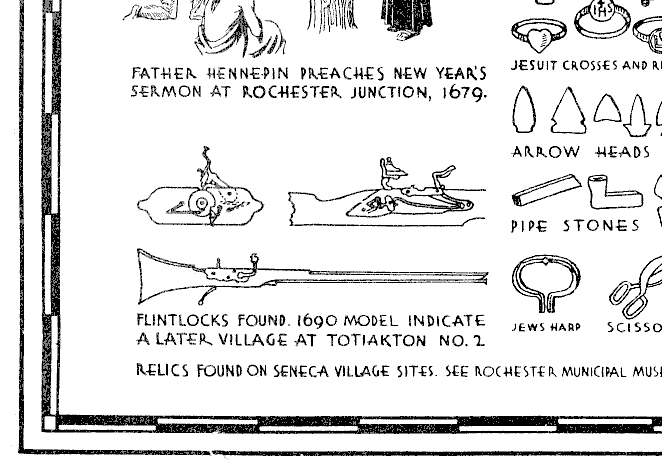
Mass by Fr. Hennepin[9] -- 
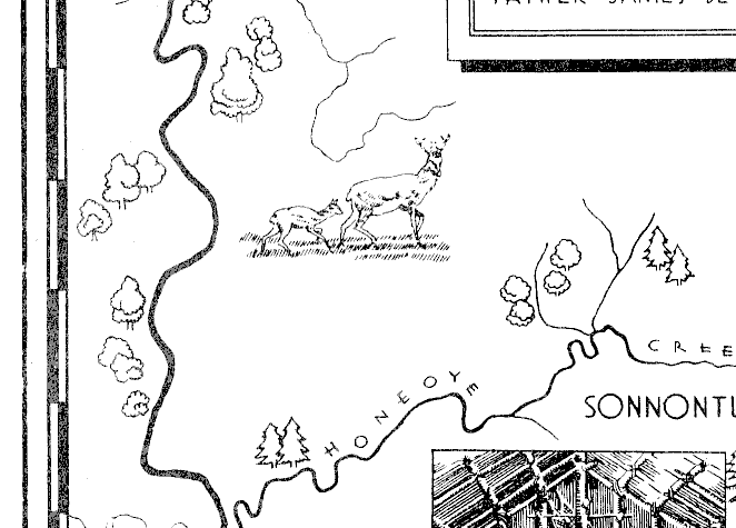
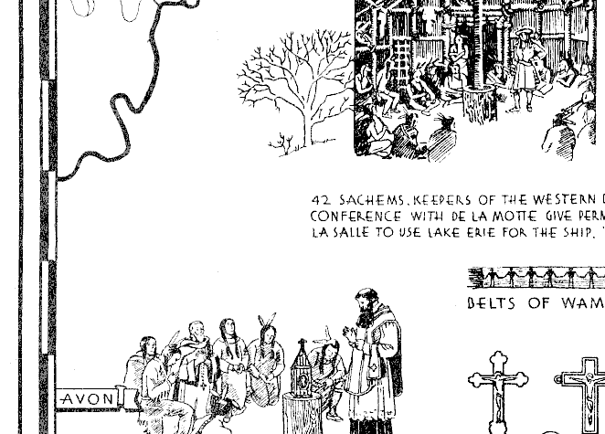
lower left, 6A:7A, belts of wampum and conference at Sonnontuan). 
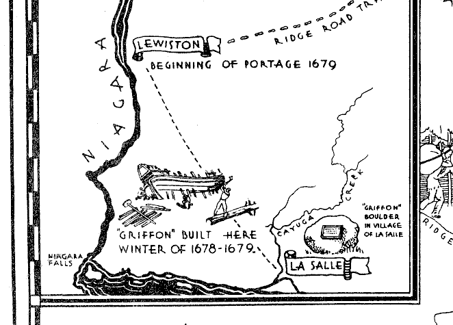
The Griffon, 2A, first vessel to sail on Lake Erie and up the St. Clair River past the present site of Detroit into Lake Michigan, was loaded with furs near Green Bay Wisconsin, and sent back on its return voyage. It never was heard of again. In order to cover this loss, LaSalle, walking much of the way, went back East and organized another expedition with which he explored the Mississippi river and mouth, completing the exploration which had been begun by Joliet and Fr. Marquette. Henri de Tonty of the silver hand, whose father was author of Tontine life insurance, was master of Fort Crèvecoeur[10] near the present Joliet, Illinois. A valuable fur trade was stimulated between the Illinois Indians and Québec: the French undertook to protect the Illinois from the Iroquois, their enemies. The Iroquois, made arrogant by many conquests, attacked the Illinois with deadly fury but ultimately were defeated.


1683-84. These dates mark the time of withdrawal of all French missionaries and all Frenchmen from the country of the Senecas and the cantons of the Iroquois. This withdrawal was made necessary in prospect of Governor de la Barre's expedition to Hungry Bay (upper right inset, 3D). This expedition consisted of several hundred sick and starving Frenchmen, with a big-mouthed Iroquois chief telling them that he had begun to suspect their friendly intentions and that had he not interfered, the boys and old women from his village would have come out had put an end to them with their bows and arrows. This expedition had no effect.


Denonville's expedition (1687)[11] (See fort at mouth of Irondequoit Bay, 1B:2B ) and follow arrows and dashes, noticing dates), with 2400 men on a scorching July day, crossed Monroe County. Many members of this expedition wrote accounts [12]. After burning the Seneca villages and destroying the corn, Denonville encamped at Mendon Ponds, 5B and near Sea Breeze, then went to Niagara and built a fort where he left 100 men (upper left, 1A ), all but 12 of whom starved or died of scurvy, or were eaten by wolves while outside cutting wood in the snow. The Senecas retaliated by a punitive expedition to Lachine on the outskirts of Montréal, where they captured 120 persons, who didn't live very long. The Senecas from the Victor area moved toward the sites of Canandaigua and Geneva. The West Senecas after some years moved to Zonneschio on the Genesee River.

Father Garnier and two other missionaries returned after 1700. A treaty was made between France and England in 1724 but was not enforced. Father Vaillant de Geulsis became the first Christian minister of any denomination in Cadillac's post at Detroit.


The break in the time of Peter Raffeix in 1672[13] was occupied by a year at Great Gully Brook, beside Cayuga Lake (see second Catholic chapel), supplying for Father Stephen de Carheil[14], who had to leave this post for a year on account of his health. Father Pierron, who confessed to his Superior the sin of homesickness, was later sent by a kindly Superior on an errand to France. Father James Bruyas, a great linguist, assisted in making the peace between the Iroquois and the French, which lasted for 50 years. This was not until after Governor Frontenac had made a raid on Onondaga in 1696. None of these missionaries were martyrs. They were honest, heroic and faithful men. Most of them lived to old age, no doubt recommending piety as a recipe for longevity.

French influence continued to be active in Western New York until 1759, when an English Colonial army took Fort Niagara from the French.


Standing on one of these village sites, from where the little streams flow all the way to Québec, hunting their father, the sea, one can feel again the tug of the tump line on the head and the scald of the paddle handle on the sunburned shoulder as an Empire attempts to go over the portages. One can feel the zest of the racing wind and of deep paddle thrusts as canoes struggle against the waves of ten thousand lakes. One can feel the agony of the burning captives and sense the triumph of an Indian tribal conquest. One can hear the cry of the wolf and the heavy noise as a moose or small herd of buffalo push through the valley. One can see the flight of a million wild pigeons darkening the sun and hear the honking of the wild geese as they go north. One can smell pungent smoke and hides drying for their long journey to Paris. Then at evening, when the sun is painting all the west in an autumn glory, one can hear an eloquent priest transfigure that sunset into the wonders of a golden Jerusalem with all the pathos of a hunger which only Eternity can satisfy.


***

Reprints of all the official Jesuit letters and a complete encyclopedia of Jesuit history of northeastern America, together with letters written in Monroe County before 1700, and life sketches of Seneca missionaries as well as of several hundred other Jesuits, may be found in The Jesuit Relations and Allied Documents. There are 73 volumes with index. There are six sets in Rochester, N.Y. (See Colgate-Rochester Divinity School, St. Bernard's Seminary, Reynolds Library and Historical Section at Public Library, Rochester.) Large libraries and Catholic colleges usually have them. There is one at Nazareth College, Rochester.

Jesuit Missions in Sonnontuan, by Reverend Charles Hawley of Auburn, date 1883, a report of the Cayuga Historical Society, gives in eighty pages the principal story of the map with letters written from Seneca village sites before 1687.

Books on allied subjects: Ignatius Loyola by Francis Thompson; Ignatius Loyola by Paul van Dyke; Father Marquette by R. G. Thwaites; Father Marquette and M�re Marie of the Ursulines by Agnes Repplier; The French in the Heart of America by J. H. Finley; Government and Institutions of the Iroquois by Lewis H. Morgan; The Archeology of the Genesee Country by Frederick Houghton.

Concerning Father Stephen de Carheil, missionary to the Cayugas at second Catholic chapel: Un admirable Inconnu or Life and Letters by Father Orband, Paris, 1890. Untranslated unique copy in possession of Wisconsin Historical Society, Madison, Wisc.

Personal correspondence between 1670 and 1700 in possession of Viscount Alain de Carheil, Carentoir, Morbihan, France (August, 1930).

***

Footnotes

1. Thwaites, Jesuit Relations and Allied Documents; Hawley, Jesuit Missionaries in Sonnontuan, or Early Chapters of Seneca History

2. Dean Harris, Early Missions in Western Canada; Hawley, Jesuit Missions at Sonnontuan.

3. Edna Kenton, Jesuit Relations and Allied Documents (abridged) contains letters of martyrs. Omits all Seneca history, for which see Jesuit Relations.

4. Louis XIV's Diary: A King's Lessons in Statecraft, p. 124, A & C. Boni, 1925.

5. Colonial Documents of New York, Albany

6. Harvard Graduate Magazine, Dec. 1928, p. 183, "A Harvard Graduate Who Beat the Dutch," by Alex McAdie.

7. Arthur C. Parker, An Analytical History of the Senecas, Researches and Transactions of the New York State Archeological Association, 1926.

8. Greenhalg: Documents Relative to Colonial History of New York, Vol. III, p. 251.

9. Hennepin, New Discovery, edited by Thwaites. Note, Hennepin and other members of the clergy associated with LaSalle were not Jesuits. Hennepin's claim that he went to the mouth of the Mississippi before LaSalle is untrue.

10. Parkman, LaSalle and the Discovery of the Great West

11.Denonville, Colonial Documents of New York

12. Fr. Beschefer, Jesuit Relations. Fr. Beschefer was one of eight or ten Jesuits who came with Denonville; La Hontan, Voyages to America: see picture diagram of battle at Victor; de Baugy, Journal, in Rochester Historical Society Publication Fund Series, vol. IX, 1930, translated by Nathaniel S. Olds; de Baugy, Journal, translated by Mrs. Atkinson Allen and Mrs. George B. Selden, October, 1931.

13. Hawley, Early Chapters of Cayuga History.

14. See de Carheil reference in text of this document.

[Top] John S. Allen's home page
[Up] Alexander M. Stewart
[Previous] Map home page
[Next] Detailed instructions

Map copyright 1931, 1955,
Alexander M. Stewart, Helen Erickson
Additional content copyright 1997 John S. Allen
Last modified December 8, 2002


  A B C D  


1

Map panel 1A Map panel 1B Map panel 1C Map panel 1D  


1


2

Map panel 2A Map panel 2B Map panel 2C Map panel 2D  


2


3

Map panel 3A Map panel 3B Map panel 3C Map panel 3D  


3


4

Map panel 4A Map panel 4B Map panel 4C Map panel 4D  


4


5

Map panel 5A Map panel 5B Map panel 5C Map panel 5D  


5


6

Map panel 6A Map panel 6B Map panel 6C Map panel 6D  


6


7

Map panel 7A Map panel 7B Map panel 7C Map panel 7D  


7

  A B C D