Top: Home Page
Up: Table of Contents
Previous:
Next:


COMMENTS ON PROPOSED
BELMONT BKEWAY

These comments are in response to an e-mail posting by John Brennan, which included the following information:

There is a plan to create a trail on the McLean property from Beaver Brook Reservation to the Clark Street Bridge. It would then follow Royal Road to Belmont Center, Channing Road to Alexander Ave, use an underpass to cross under the rail line to the High School area and continue east to the Fitchburg Cutoff. The project is on hold for the moment due to lack of funds.

I obtained further information about the proposed trail  at the Belmont Bicycle Committee meeting of May 22, 2001.

First, let me state my opinions about proposed routing between Waltham and Alewife Station.

Routing from Waltham to Alewife

While the idea of a continuous bicycle trail connecting Waltham to Alewife Station fires the popular imagination, I conclude after attending the Bicycle Committee meeting on May 22 and reviewing proposed routes, that a successful transportation route from Waverly Square through Belmont Center can be achieved easily on streets, but not on a trail.

Routing on the Fitchburg Line rail corridor, as suggested in the past, would indeed be very direct, and flat, but was dropped from consideration because of problems of sharing the corridor with an active rail line, getting past the platforms at Waverly station, and concerns of residents. The proposed routing through the McLean property is not practical as a transportation connection between the Beaver Brook Reservation and Belmont Center. The route is too circuitous, too hilly and involves too many waits at pedestrian-type crossings to be attractive for transportation use. However, there are other valuable uses for trails on the McLean property (see below).

Two alternative routings Between Waverly Square past Belmont Center look feasible to me. I suggest that they both be explored. Both could be implemented at the same time, and would serve different neighborhoods. Most parts of these routes are already attractive enough that they are indicated on Boston's Bikemap (from Rubel Bikemaps).

  1. Trapelo Road to Pleasant Street (with repaving and widening as already planned) to Alexander Avenue, Alexander Avenue to Channing Road and the proposed rail underpass behind the High School. The major difficulty of this routing is with the intersections at Trapelo Road. However, this problem can be addressed by improved signalization and striping, street widening and/or relocation of a few parking places.

    What is needed is a dedicated left turn lane (to be used by bicyclists and motorists) for the turn eastbound from Trapelo Road onto Pleasant Street, and another dedicated left turn lane for bicyclists proceeding westbound, leading to the path system at Beaver Brook Reservation. (A bicycle-friendly left turn lane from Trapelo Road onto Waverly Oaks Road is also desirable, as it connects with neighborhoods not accessible via the trail, will provide faster travel when the trail is crowded, and is of adequate width for bicycle/motor vehicle lane sharing.).
  2. Beaver Street to Sycamore St, to White Street, crossing Trapelo Road onto Waverly Street, to School Street, then left to Concord Avenue at Cottage Street and/or the High School entrance roadways (preferably taking advantage of existing signals)

    This alternative would benefit from a traffic signal at Trapelo Road and White Street (replacing the mid-block pedestrian signal west of White Street) and from moderate traffic calming measures on the secondary streets used. Such traffic calming measures are popular with residents. When properly implemented, they discourage through travel, allow access by emergency vehicles, delivery vehicles and residents' motor vehicles, and allow bicyclists to travel unimpeded. An example of this approach already exists in Belmont -- there is already a barrier just north of Alexander Avenue in Belmont Center. It clearly was installed at residents' urging, to keep through traffic out of their neighborhood.(Much more sophisticated barrier designs are, however, possible, and are used in some American cities.) My two proposed routes would connect with each other at Waverly Square.

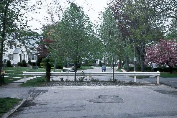
Traffic-calming barrier in Belmont Center
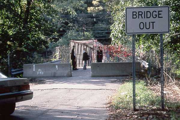
9905N11R24BelmontBarrier.jpg (48814 bytes)


Alternate concept of trail

If a trail on the McLean property is not to be considered as part of the through route, it should still be considered as a civic amenity, and it may have some transportation utility for local trips.

I think that such a trail can be more successful if it is relieved of the burden of attempting to make it into a part of the Wayside Rail Trail system, because then it can be optimized to serve the goals of local access and recreation better, and to avoid some safety problems with the present proposal.

I suggest that this trail not connect with Snake Hill Road. I was pleased that pedestrian and bicycle access was restored at the Clark Street Bridge after motor vehicle access was discontinued, but I have serious concerns about taking a bicycle trail across Pleasant Street at this location. My reasons


The Clark Street Bridge

0103R04R24clark st bridge.jpg (50092 bytes)


  • Snake Hill Road is very steep. Some bicyclists will have to walk up the hill -- not a serious safety problem, but one that will discourage them from using the route. In the downhill direction there is a serious safety issue. Child and novice bicyclists (and even worse, inline skaters) who can not control their speed will find themselves headed out into Pleasant Street opposite the flow of traffic.

  • Snake Hill Road and the Clark Street Bridge are lightly used at present. If they became part of a trail system, problems with traffic flow will occur, as well as collision hazards due to the larger volume of cross traffic. These are some of the same problems that led to the discontinuation of vehicular access at the Clark Street Bridge. The hazards are an especially serious problem for the novice and child bicyclists who are likely to use a trail. The Clark Street Bridge is of substandard width for a bicycle trail.

  • The underpass at the Belmont train station is too narrow for a bicycle route -- even one-way, as pedestrians would use it in both directions -- and the circuitous access to the underpass also is a problem. Perhaps a trail in the McLean area could be brought down to Pleasant Street nearer Waverly Square, where there need not be as steep a slope and where vehicles already have to travel slowly. I notice that there are a couple of existing rights of way on the McLean property which come down to Pleasant Street.

The lack of a trail leading to Snake Hill Road does mean that children could not use the trail system to get to Belmont Center. However, Waverly Square provides good shopping and access to public transportation. Frankly, I consider Waverly Square a more important destination for a path from the McLean residential and business developments than Beaver Brook Reservation. A direct path to Waverly Square would promote bicycle and pedestrian trips for shopping, as well as public transportation use. The entrance road to the McLean area, on Mill Street, already provides a reasonably direct route to the Reservation. The improved pleasant Street will provide a good connection into Belmont Center, except for child and novice bicyclists. A trail on the rail line from the train station across the Stone Bridge to Alexander Avenue would be a useful connection through Belmont Center, particularly for pedestrians wanting to get to the rail station. It might also connect to Concord Avenue near the police station. This would provide a good connection to Pleasant Street without the complications of the Clark Street Bridge/Royal Road/underpass route.

Issues east of Belmont Center

A route on Channing Road would be attractive if the existing access from the cul de sac at its end to Brighton Ave. can be formalized. Channing Road carries very little traffic, thanks to the cul de sac. Or a route could go through the proposed underpass behind the High School. A route on Concord Avenue could use the High School entranceway, following its one-way travel pattern in both directions, or could use streets east of the High School, in either case coming out onto Brighton Avenue at Hittinger Road.

Bicycle routes on sidewalks

I notice that several sections of the proposed route are on sidewalks or on paths to be located next to the road like sidewalks. This type of routing is undesirable because intersections with streets and driveways create conflicts which it is difficult for bicyclists and motorists to avoid. In addition, the proposed sidewalk routing in Belmont includes several sharp right-angle turns at corners, which are substandard for bikeways and pose additional risks. Travel on such routes is slow, and they have been shown repeatedly to have a higher car-bike collision rate than riding in the street (see discussion of technical problems and research findings). Also, sidewalk routing places bicyclists in the wrong side of motor vehicle headlamp beams. The AASHTO bicycle facilities guide has a long list of additional reasons to avoid this type of routing. Turning and crossing collisions are common; overtaking collisions are rare.