Top: Home Page
Up: Table of Contents
Previous:
Next:
| In the late 1970s, the bicycle path on the Boston side of the Charles River was
extended under the Boston University Bridge, and as far as Cambridge Street. Some of the
photos below are in black and white. They were taken shortly after the path was extended.
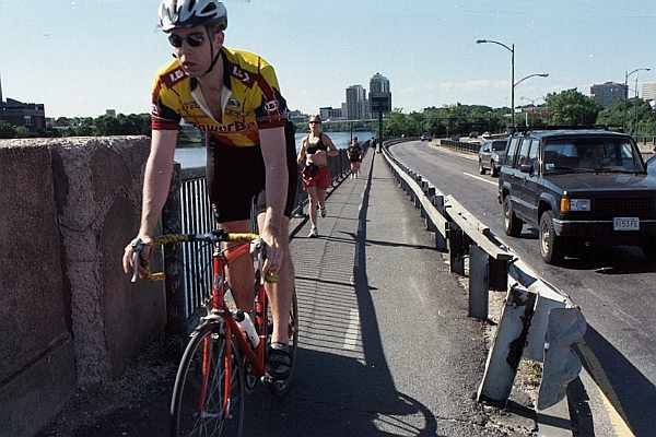
There have been few changes in this section of the path since then. This section of path is one of the most seriously compromised in terms of safety, especially at its western end when it is crammed in between a retaining wall and an exit ramp from Storrow Drive. The photos here will illustrate some of the problems, as well as a major opportunity to provide a useful connection at a relatively low construction cost. *** As the path approaches the BU Bridge, it curves sharply around the Boston University boathouse, which creates a sight line obstruction. The centerline stripe and directional arrows are a recent and significant improvement, but the center stripe should be solid, not dashed, on a blind corner. |
Sight line obstruction created by boathouse
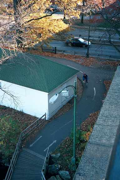
| The path continues on a wooden underpass under the BU Bridge, built in the late 1970s. Until the underpass was built, the path extended only as far as the BU Bridge.The underpass is shown in the photo below. It creates an important connection, but it does not meet bicycle path design guidelines. The wooden surface is slippery when wet, and the railings are too close to the path at the inside of the turns. In the background of the photo are the BU Bridge and, at the right, a railroad underpass. |
Wooden underpass under the BU Bridge
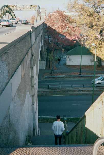
| The photo below shows the underside of the BU Bridge as it
passes over Storrow Drive. The river and the wooden underpass are out of the picture to
the left. Beyond the BU Bridge, you can see the bicycle path on the left and Boston
University buildings on the right. A problem in this part of the path is lack of access to streets. There is an overpass over Storrow Drive several hundred feet east of the BU Bridge, but it has only stairs, no ramps. A few people, like the man in this photo, run across Storrow Drive to get to the path and the boathouse, visible under the left end of the bridge arch. |
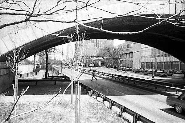
| Pedestrians' tendency to cross here is encouraged by the stairs from the BU bridge. The path and boathouse are visible at the rear in the photo below. |
| Access to the streets could be provided relatively easily. The photo below, taken from the west BU Bridge sidewalk, shows the Boston end of the railroad bridge and of the wooden bicycle underpass, with the bicycle path extending to the right. The first road beyond the bicycle path is Storrow Drive, and the one at the very top of the photo is the Massachusetts Turnpike. Notice that one track of the two-track railroad bridge is not in use, and that it would be easy enough to construct a ramp up from the path to the railroad grade. And there's more... |
Looking upstream from the BU Bridge
along the rail line and bicycle path.
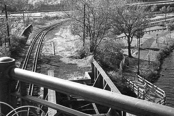
| Looking to the left from a position near the rear of the photo above, a connection to street level is possible. The railroad line carries only one or two trains per day at the most, so crossing the tracks is not a serious issue. There is already a bicycle/pedestrian crossing of these tracks in Cambridge. |
View toward Commonwealth Avenue from
railroad tracks. Massachusetts Turnpike
in underpass at right.
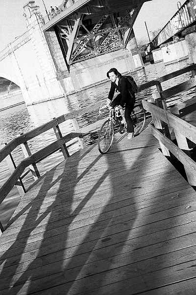
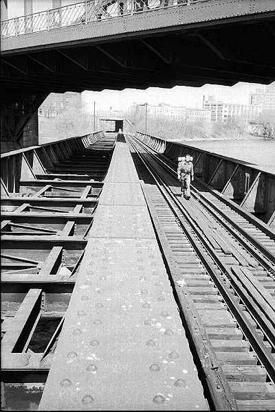
The nonchalance of the pedestrian in the photo below makes the point of how little rail traffic uses the railroad bridge. The photo also shows how the railroad bridge passes under the BU Bridge while crossing the Charles River . The empty half of the railroad bridge could carry a path which would connect to the parkland on the Cambridge side of the river, and through the underpass in the background, under Memorial Drive to Cambridgeport and the Massachusetts Institute of Technology. These routes would be more attractive and shorter for many bicycle and pedestrian trips than routes using the BU Bridge.The Charles River lower basin plan published in 2001 recommends that the underpass be used in this way. There has also been discussion of using it as a busway. |
Railroad bridge under the BU Bridge
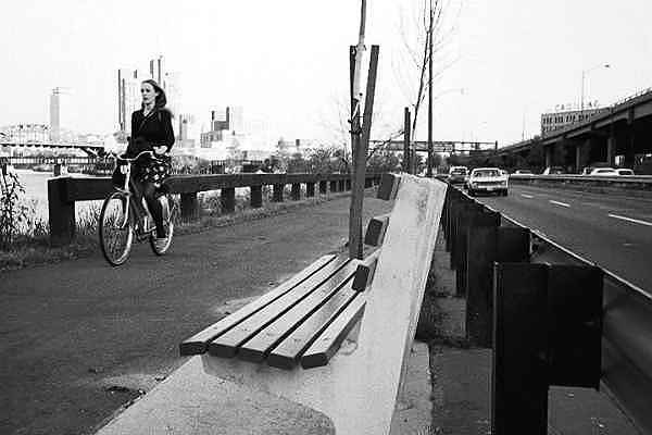
Proceeding west along the path toward Cambridge Street, there are other issues. Any users of the park bench in the photo below would have motor traffic whizzing past their ears and bicycles running over their feet The bench would have been better facing the river on the other side of the path, or perhaps at another location entirely. Several other benches along this stretch of path are placed too close facing the path. The Metropolitan District Commission is still placing benches this way twenty years later. |
Park bench placement between
BU Bridge and Cambridge Street
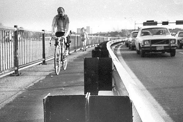
| The corridor for the path becomes very narrow, and its width is
substandard as it approaches Cambridge Street. As shown in the photo below, the pavement
closest to the river consists of the tops of the stones of the old retaining wall, whose
construction predates that of the path. The rest of the path's width is paved with
asphalt. The uneven joint between them can make it impossible for a bicyclist to balance.
Bicyclists riding away from the camera also are facing into the bright side of motorists'
headlamp beams when riding at night. The railing on the river side predates the path construction and does not have a handlebar rub strip, but it is tall enough to avoid any substantial risk of bicyclists' falling into the river. The railing on the highway side is shocking: too low, and with I-beams facing the path which can catch a bicycle pedal. A bicyclist who collided with this railing would either land on top of the sharp posts, or topple over into the Storrow Drive exit ramp. |
Multiple hazards from railings and irregular pavement (1978 photo).
| The photo below was taken in 2001 at the intersection of the path with the Cambridge Street (Boston)-River Street (Cambridge) bridge. Sometime in the early 1980s, wooden planks were bolted to the I-beams, somewhat reducing the risk of catching a pedal. The planking does not extend to the lowest position of a pedal, and has not been maintained well. The width of the path and the height of the railing on the highway side are still substandard. A center stripe has been painted on the path, and a new layer of pavement covers the crack at the edge of the retaining wall. The pole for the signpost in the background might have been placed inside the width of the railing but instead, it intrudes into the already substandard path width. |
Path at Cambridge Street, 2001