Top: Home Page
Up: Table of Contents
Previous:
Next:
CHARLES RIVER ROAD, WATERTOWN:
|
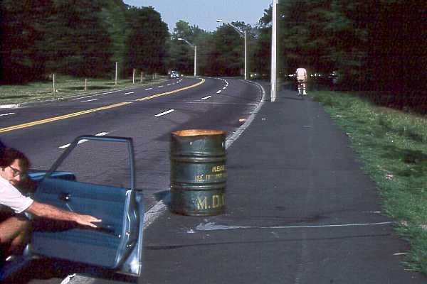
There must be an interesting history to the construction of Charles River Road as a four-lane road where two lanes would have been sufficient. I suspect that the construction was a 1950's project which reflected a too-close relationship between politicians who distributed tax dollars, and contractors who spent them. Besides its boondoggle characteristics and the intrusion into the riverfront parkland, the wide roadway impedes pedestrian access to parkland from adjacent residential areas and the Perkins School for the Blind. In 1980, the Paul Dudley White Bicycle Path extension was built along the river side of Charles River Road. It is my understanding that the path was originally to have been set back from the road, but park advocates insisted that it be built adjacent to the road, so as to reduce further intrusions into the parkland. Until Charles River Road was restriped, I was annoyed by the implicit assumption behind construction of the path, that it was a good place for bicyclists to ride, while the road was no place to ride. In reality, the path was useful to provide access to the parkland for pedestrians, and for casual bicycling, but it is not very safe when more than a few people are using it, or for faster bicyclists. The remaining photos, which I took in 1982, illustrate conditions on the path. They have not changed significantly since then. For a considerable part of the year the path was, and is, completely unusable. In the winter, it is a dumping place for snow plowed from the roadway. Piles of snow remain for weeks after the roadway is clear. The path was built using transportation funding, as a transportation route. The conditions illustrated in the photo stretch that concept a bit. |

Near the Watertown Square end, cars frequently park next to the curb and there is a risk of being doored -- on a bicycle path! -- or of a head-on collision between bicyclists who have swerved to avoid an opening car door or a person getting out of a car. On the day I took the photo, the Metropolitan District Commission had placed a trash can on the path, lending additional meaning to the expression "mixed-use path.". |
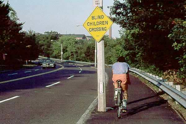
The path was built to the 8-foot minimum width specified by AASHTO guidelines, except for the minor detail that that light poles were within that width. The 1980 construction of the path preceded the 1981 revision to the AASHTO guidelines, which introduced a specification for shy distance at the edges of bicycle paths. As shown in the photo below, a guardrail was installed along part of the path on the side opposite the road, with no setback. Bicyclists slow down to avoid passing each other where they are squeezed between the guardrail and the light poles. A bicyclist who strays into the guardrail topples over it and down an embankment. A bicyclist who strays off the other side of the path goes over the curb, most often facing toward traffic. If a car goes off the road, the guardrail guides it into the next bicyclist or light pole. I'm not sure what the point of the "Blind Children Crossing" sign is in the photo above, with no crosswalk or traffic signals anywhere in sight. Since I took the photo in 1982, the sign has disappeared. |
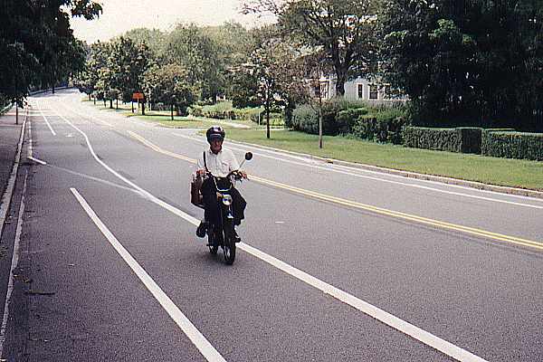
| I knew the relative risks, and so I usually would ride in the road rather than on the
path. With the four-lane striping, the lanes were too narrow to share, so I would take my
position in the middle of the right lane to force drivers to merge to the next lane to
overtake me. No driver ever was delayed by this, because the traffic was so light. Now, with the restriping, motorists are probably less annoyed with my riding on the road. And I am less annoyed too, even though no improvements have yet been made to the path, and none probably will be. Watertown officials indicate that motorists used to travel at excessive speeds on Charles River Road, and this problem is now reduced. As I indicate in some of the other pages on this site, I think that designated bike lanes are frequently installed where inappropriate. However, on Charles River Road, their problems are relatively few, because there are so few places where motorists can make turns. All in all, Charles River Road is much improved now, though it still has a ways to go. My first priority for an improvement -- one I suggested in the corridor study but which was not implemented -- would be a signalized pedestrian crossing behind the Perkins School, to relieve the irony of the "Blind Children Crossing" sign. The recently published Charles River Lower Basin plan includes a proposal to reduce the width of Charles River Road. I hope that it is not narrowed so much that motor vehicles no longer can pass bicycles safely. In sections where there is parallel parking on one side, it is none too wide as it is now. |