Top: Home Page
Up: Table of Contents
Previous:
Next:
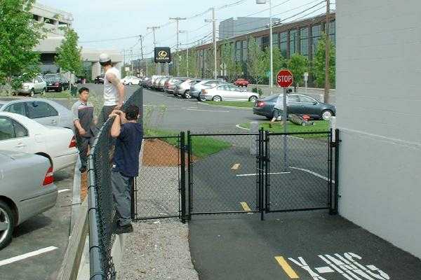
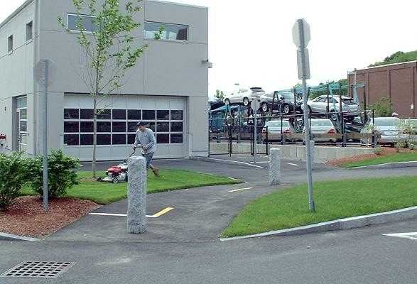
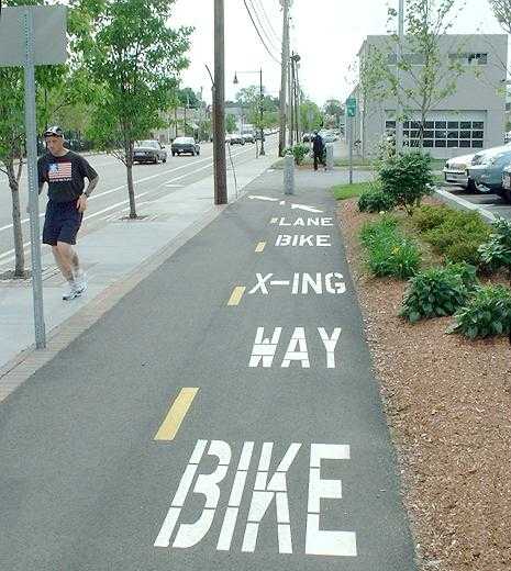
In 2004, a bicycle path was built along Arsenal Street in Watertown in front of the Lexus dealership just west of School Street, then leading away from the street through the property of the dealership. A section of the path is shut off by locked gates. The path appears to be an attempt to extend a proposed rail trail that would lead along the Watertown Branch rail line from Fresh Pond Park in Cambridge to School Street. The rail corridor would generally be a reasonable for a trail. It would provide a shorter route than streets for many trips, and it crosses busy Huron Avenue and Mt. Auburn Street with grade separations. There is one difficult intersection at Arlington Street. However, the railbed was sold off west of School Street in Watertown. Some compulsion to continue the trail in the face of overwhelming difficulties appears to underlie the construction of the sidepath. The sidepath has serious deficiencies, not only in the conflicts inherent in any sidepath with driveway and street crossings, but also in the details shown in the photos below. And, strangest of all, it is closed off by two gates so that it does not go anywhere that Arsenal Street doesn't already go. Arsenal Street already has Share the Road signs, and bike lane stripes -- though, as on North Beacon Street, there are only stripes -- no signs or markings. I understand that the people who promoted the path are passionate about 'finding a traffic free route to Watertown Square for residents'. A path that crosses several driveways, a major street and a parking lot is hardly "traffic free". Research has shown that a sidepath with street and driveway crossings has several times the car-bike collision rate of riding in the street. Passion is, unfortunately, no substitute for engineering judgment. I think I can see what happened here: a promise exacted from the developer, shoddily carried through following a series of compromises that reduced what was a questionable effort in the first place to complete nonsense -- but a a stubborn unwillingess on the part of the advocates to back down and let the developer "win", coupled with a lack of imagination. Suppose that the developer had instead been asked to contribute to a fund to produce a better facility elsewhere, for example bicycle parking racks in the Watertown business district, or a different trail? That would have been a win-win instead of a lose-lose. A tour of the pathLet's see what we got for the developer's money. The west end of the path leads to a parking lot accessible only from Walnut Street. The end of the path is blocked by a locked gate as shown in the photo below. The pavement ends at the gate, and does not extend to the edge of the parking lot. |
Locked gate at west end of path, looking east.
Pavement ends at gate. Parked cars also block exit.
| The path proceeds eastward past a building which is part of the Lexus dealership. Here, the path would offer the rather unique risk of being "doored" by a building rather than, as is more usual, a parked motor vehicle, if this section weren't blocked by a locked gate at each end. |
Door zone hazard, looking west toward the gate shown
in the previous photo.
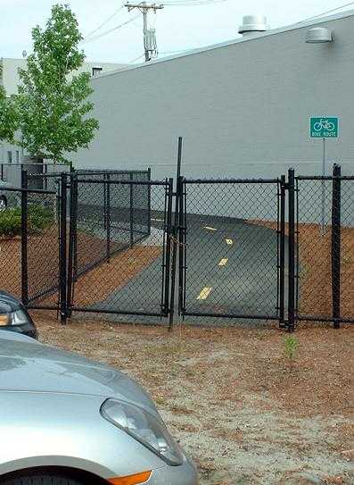
The path passes close to other end of the building, where there is a blind corner, blocked by the other locked gate. The gate is painted black and is unreflectorized. Beyond the gate, the path is constricted between a stop sign post and a granite bollard, neither of which is reflectorized or painted in a bright color. |
East end of the building with locked gate,
blind corner and hazards at driveway
Here we look back at the gate from its east end,
Note blind corner (left) and that even if the gate
were open, the gateposts would still be a hazard --
unreflectorized, dark and directly adjacent to the trail.
We now continue backing up along the path, to the east. The path continues around the front of the building. The purpose of the handsome granite pillars here apparently is to keep motor vehicles off the path and to provide an artistic accent. It has been well-documented since 1979, with the publication of the Eugene, Oregon bicycle plan and study, that posts in the middle of a path pose a hazard. As there is a driveway leading straight into the garage, and motor vehicles can't turn on a dime, the posts are a brain-dead solution looking for a problem, perhaps the work of landscape architects posing as traffic engineers. |
Continuation of path past front of building across two driveways.
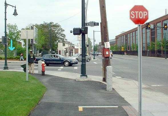
We now move to the east end of the path for our next photo, and head back toward the middle. The east end of the path at School Street is a real obstacle course. The granite bollard at the right, mercifully, is not aligned with the 4 foot-wide diagonal crosswalk ramp. |
East end of path, view from across School Street
| Looking at the School Street end of the path from the other direction, we can see the end of the railbed (marked by the blue arrow in the photo below). Travel between it and the sidepath would be by the indirect route along the sidewalk to School Street, then the crosswalk and diagonal ramp. |
View across School Street from the west
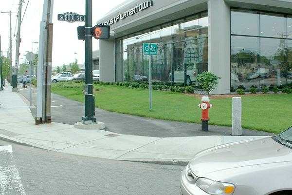
| Now we turn west, and we pass the driveway entrance of the Lexus dealership, with its granite bollards and stop sign. A bicyclist riding in the street to the left would not have to stop, or yield to conflicting traffic, and would not have to look in three directions at once -- left, right and behind. |
View looking west across driveway at front of Lexus dealership
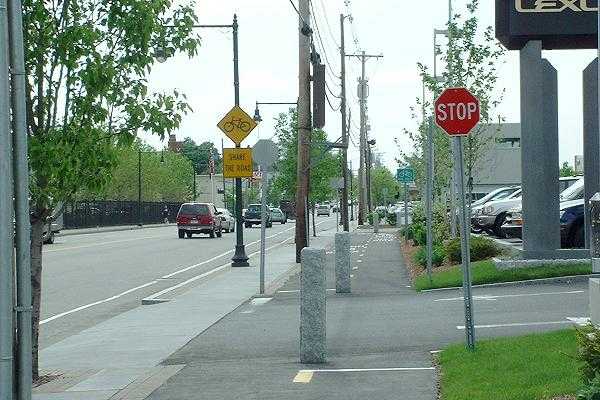
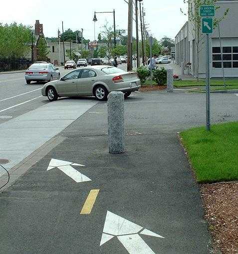
Past the driveway, the path is painted with large markings indicating that bicyclists headed for the bike lane should pass to the left of the granite bollard at the next driveway -- head-on toward bicyclists coming in the opposite direction. Also note the sign in the foreground of the photo below, too close to the path to conform to national design guidelines, and the loose guy wire next to the utility pole near the middle of the photo (where the arrows point). |
Drivers like the one in the photo below, exiting the next driveway, must yield to several streams of traffic on the sidepath, sidewalk and street. If the path were open, one of these streams would coming from the trail at the right rear of the photo, in the drivers' right rear blindspot. Yielding to traffic only on a sidewalk and in the roadway would be much simpler. Eastbound traffic along Arsenal Street has no way to transition to the sidepath except to cross the street between intersections. It is much easier and faster to ride up to the intersection at School Street. With the gates on the continuation of the path, there is nowhere for eastbound traffic on the path to come from. That black loop sticking out at the left side of the picture is the loose guy wire, nicely positioned to snag a bicyclist's foot or pedal. |
West end of sidepath segment along Arsenal Street. The sign
at the
upper right reads "to Arsenal Street Bike Lane."
There is a stop sign here for motorists exiting the driveway;
none for the sidepath.
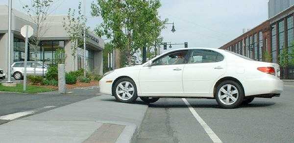
| A Lexus employee explained that the dealership is unhappy with the installation because of a requirement for a steep ramp from the street, which can scrape the underside of the new cars the dealership sells -- the photos above and below illustrate this problem. The steepness results from the need to place the sidewalk closer to the street to make room for the sidepath. |
Steep ramp from street
All in all, this is the most bizarre bicycle facility I have ever seen. It is
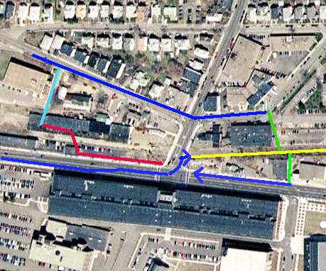
slow, annoying and hazardous, like some others. But in addition, it is completely useless!What would be better?Arsenal Street runs from right to left across the bottom of the aerial photo below. School street runs from the middle upward. This photo was taken in 1995 -- the Lexus dealership on the northwest corner of Arsenal and School Streets has replaced the black-roofed building shown there with different buildings. The lines drawn on the photo show:
It is this author's opinion that the connections I have proposed, or something like them, would work much better -- faster, and safer. Other connections have been proposed as well, to the paths along the Charles River: see http://www.pathfriends.org/bemis/ |
| Thanks to Tom Fine and Kat Anderson for editing and proofreading assistance with this page, and to Bryce Nesbit for suggesting the link to the Pathfriends site. |