JOHN S. ALLEN'S BICYCLE FACILITIES, LAWS AND PROGRAMS PAGES |
||
 |
Top: Home Page Up: Bicycle facilities Next: Map of Franconia path |
 |
JOHN S. ALLEN'S BICYCLE FACILITIES, LAWS AND PROGRAMS PAGES |
||
|
Top: Home Page Up: Bicycle facilities Next: Map of Franconia path |
|
Epigraph: two views of the pathI do know that one ten year old had a cycling accident while descending the Franconia Notch bike path. I heard his bike brakes failed, and he crashed at what was described as a 60 mph speed. The victim was helicoptered to Dartmouth Hitchcock Medical center with what were said to be severe head injuries. -- a correspondent who wishes to remain anonymous The White House Millennium Council designated the 8.8 mile Franconia Notch Recreation Trail (known to many as the "Bike Path") as New Hampshire's "Millennium Legacy Trail." Each of the fifty states has a Millennium Legacy Trail chosen by the council, though no federal funding accompanies the honor. -- Appalachia, the magazine of the Appalachian |
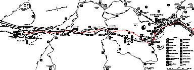
Map showing location of the bike path
| Ahh, the Franconia Notch (New Hampshire) bicycle path...Let me begin here by quoting
an article that appeared a few years ago in The Ride, the New England regional
bicycling magazine: "I came to a respectful stop atop the hill. Scratch that. Chute,
is a more appropriate term. Ahead of my front wheel unraveled a ribbon of asphalt that
poured down a terribly steep slope...Welcome to the Franconia Notch State Park bike path.
Perhaps the most exciting roller coaster in New England and a great spot for a family
looking to ride bikes." (The italics are my own.) Hey, wait a minute. Beg to differ with the author of that article. How many helmetless six year olds on Huffys can you launch down that hill before one of them gets taken away in an ambulance? |
The Chute. (C on map,
looking west)
|
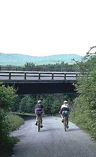 |
How steep?
The bicyclists in the photo above
are descending the slope at the left in
the photo below.
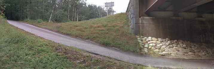 |
Under the bridge
(C on map, looking west)
No shoulder on either side,
steep slope away from right side of path (after
steep downhill curve in previous photos),
blind left turn beyond the bridge...
The Franconia Notch path may pose some interesting and attractive challenges for an
experienced rider -- but as a substandard facility with a mix of novice riders and
pedestrians, it is a guaranteed accident hotspot. I am very wary about recommending the
Franconia Notch path to casual family cyclists -- the kind of folks, God love 'em, who
take the bikes out of the garage once a year to tie them on the front of the Winnebago. Why the fiasco?The Franconia Notch path did not solve an accident problem. It created one which did not exist before. To understand why this happened, you have to understand why the path was built. For many years from the 1970's on into the 1980's, a terrific controversy raged about widening the highway through the Notch, a narrow two-laner that connected to an Interstate at each end. The Notch highway was a bottleneck, and hazardous, but environmentalists were concerned about the impact of widening it on the state park in the Notch, and that blasting might damage the Old Man of the Mountain, an odd rock formation which is [as of 2007, was] New Hampshire's most famous scenic attraction. Eventually, a design compromise was reached. The road remained two-lane, but it was straightened, and wide shoulders were added for most of its length. Ramps and overpasses were built to channel traffic in and out of the recreation areas. With limited-access designation came Federal Interstate funding and the authority to ban bicycles. But when Federal funding is used in a reconstruction that closes the only available route for bicycles, an alternate route must be provided, under a provision written into Federal law as a result of League of American Bicyclists lobbying in the 1970's. Money left over when the original four-lane plan was cut down to two lanes easily allowed for construction of the path. |
|
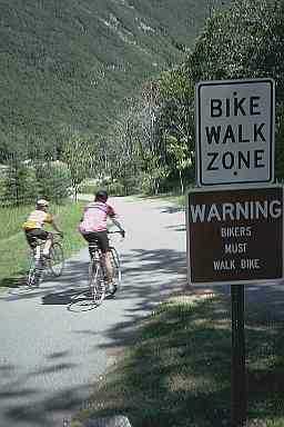
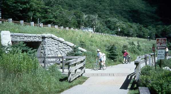
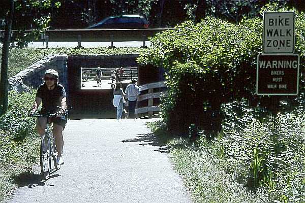
Walk signs (B on map, looking south) This part of the path connects a |
| The highway occupies the best through route in the narrow valley, and so the path
could only be built with grades and curves far in excess of AASHTO (American Association
of State Highway and Transportation Officials) design guidelines. Since the path is in a
recreational area, it attracts crowds of novice bicyclists and pedestrians. The popularity of the path would mark its success if it weren't for the crashes. The path has proven so hazardous that some sections (especially those with heavy pedestrian traffic) are now decorated with signs telling bicyclists to walk their bicycles. But a path so hazardous that you're told to walk your bicycle is, I'm sorry, not a bicycle path. It is a pedestrian path that was paid for by bicycle funding. About the path, see also the introductory page with links to the photo tour, and to a history and discussion. |
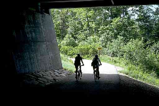
Path goes under highway
(A on map, west side of
highway looking south)
Note park bench (bottom right) placed too close
to the path; slippery wooden surface at location
of substandard turn (AASHTO requires a 50-foot
turning radius); fences and culvert wall adjacent
to path without clearance.
Same location, view from east end of culvert
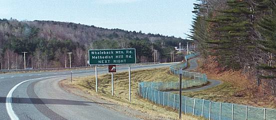
| The Franconia Notch path is not the only one to substitute for highway access in New Hampshire. There are three path segments paralleling Interstate 89 between Concord and Lebanon. One, near Concord does provide useful access, like a frontage road -- except when closed due to snow. I have seen bicyclists on it. The other path segments, along a rural section of Interstate 89 in Enfield and Grantham, get almost no use at all. I have only once seen anyone using either of them, though I have driven past them dozens of times. Allowing bicyclists to ride on the wide Interstate shoulders there would have been a practical, safe and zero-cost alternative. |
Path paralleling Interstate 89 near Grantham, New Hampshire This path, in a very rural part of New Hampshire, sees almost no use and is completely unjustifiable. At least 19 states permit bicyclists to use rural Interstate shoulders. Why not New Hampshire? |
LessonsWhat lessons does this planning fiasco hold?
The State of New Hampshire has, then, replaced several sections of nearly year-round rideable highway with a seven month per year bicycle path. This loss of access stretches the legal justification for the paths, preservation of access, beyond credibility. If the engineers had thought of preserving bicycle access on the highway in the first place, then they could also have thought about using their funding more effectively -- for example, building bicycle paths that served novice cyclists well, rather than as a way to meet the Federal requirement for an alternate route. The Notch path serves a recreational function, and is popular. I am a skillful enough bicyclist that I may someday enjoy riding it myself. [I did, in 2001, and the photos I took are on display on the Internet now.] But I am concerned about the novice riders who get into accidents on this types of facility, and the nonsense about safety which leads our governments to spend large sums of money on the wrong facilities in the wrong places. *** Some Federal laws that apply to paths replacing highway access (23 U.S.C. §109, STANDARDS)
(23 U.S.C. § 652, 4-1-90 edition)
And note that prohibition of bicycles on Interstate shoulders is at the discretion of the states. At least 19 states permit bicycles on the shoulders of some Interstates. What is so different about New Hampshire that it should not? If a bicyclist were ticketed for riding on a highway on a spring day while the roadway was clear but the path was still snow-covered, the highway prohibition would almost certainly be declared invalid in court based on the Federal statutes cited here. Any takers? |
| Top: Home Page Up: Bicycle facilities Next: Map of Franconia path |
Contents © 1993, 1997, 2000, 2007 Last revised 5 February 2007 |