Top: Home Page
Up: Table of Contents
Previous: Concord Avenue west of rotaries
Next: Concord Avenue sidepath
| As part of a major highway reconstruction project, a bicycle path has been constructed
in Fresh Pond Reservation, in Cambridge, Massachusetts. Fresh Pond is a natural pond,
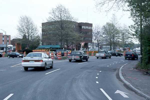
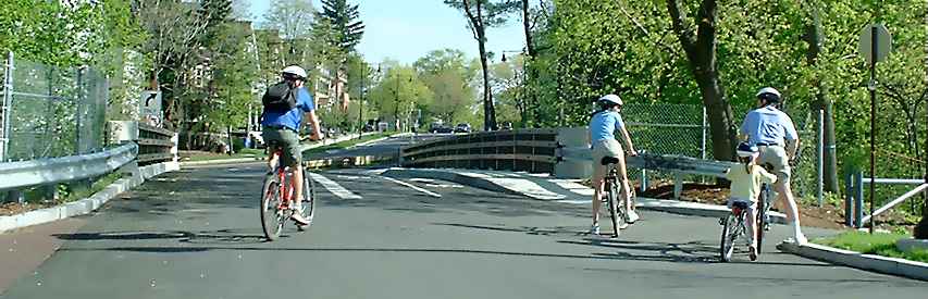
which has been adapted into a reservoir for the City of Cambridge Water supply. There has been a path around the pond for many years, but the path to be discussed here is a new and different one. It begins at the rotary intersection (traffic circle) of Concord Avenue and Alewife Brook Parkway, north of the pond. We'll take a tour of the path starting at that point, location A on aerial photo. In the late 1990s, Concord Avenue west of the rotary was restriped from four lanes to three lanes -- two eastbound and one westbound -- with a bike lane on either side. The reconfiguration significantly improved bicycling conditions, without much impact on the flow of motor traffic. The view of the rotary in the photo below is from the west Concord Avenue entrance. This photo was taken in May, 1999. The end of the bike lane is visible in the photo; it is dashed as it enters the rotary, where bicyclists must merge left if they are passing the first exit. |
Entrance to Alewife Brook Parkway rotary from
Concord Avenue eastbound, May 1999
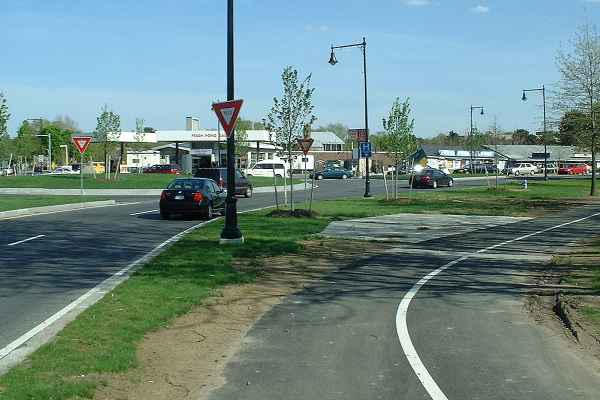
| The next photo was taken at the same location on May 21, 2002. The bike lane now ends abruptly. There is a curb cut to the right. Where does the curb cut lead? |
Same location, under construction, May, 2002, end of
bike lane and transition to path. How clearly
can a bicycle facility convey the message "get off the road"?
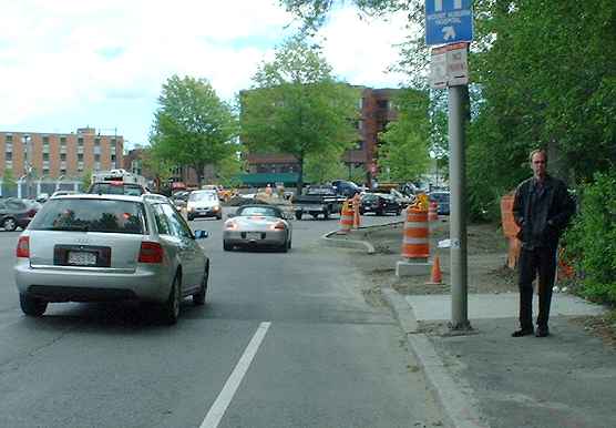
| The curb cut leads to the new bicycle path. The message for bicyclists headed east
(away from the camera in the photo above), is clear enough: "get off the road." The photo below looks back to the west along the path toward the location in the first photo. For bicyclists headed west, the path is on the left side of the road. At night, the cyclists also are riding directly into the headlamp beams of vehicles on the road. Where the path ends, it leaves cyclists on the wrong side of Concord Avenue. There appears to be a curb cut for a crosswalk in front of the gas station across from the path entrance. Bases for traffic signal posts indicate that the crosswalk will probably be signalized.. |
Looking back toward rotary from path.
| Proceeding east along the path, we come to the crosswalk which connects it with the sidepath on the other side of Concord Avenue (location B on aerial photo). Bicyclists traveling along Concord Avenue are expected to cross at this crosswalk and continue on the left side of Concord Avenue, then recross -- a very slow route. |
Crosswalk as viewed from path
Photo showing the other end of this crosswalk
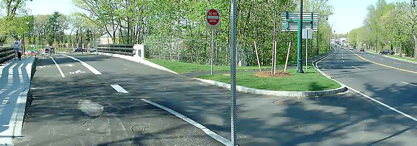
| The path in the park continues past the rotary at Fresh Pond Parkway and Concord Avenue (location C in aerial photo). There is no connection to the roadway here, and the message the path conveys is clearly "stay off the road." And, in typical New England fashion, "when you get to the second rotary, you've gone too far, so turn back." Notice that the traffic lanes of Concord Avenue are too narrow for bicycle/motor vehicle lane sharing. They were deliberately narrowed as part of this project; in order to slow and channelize traffic through the rotaries. Bicyclists on the road will now either delay motor vehicles, or vice versa, depending on how heavy the traffic is. The roadway here was never very attractive for bicycling, but it is now worse, and the designated new route on paths and crosswalks is so slow that many are sure to decline to use it. The sidepaht on the far side of Concord Avenue is also very hazardous. |
Path passes rotary at north end of Fresh Pond Parkway.
No connection to the roadway here.
Also note narrowed lanes.
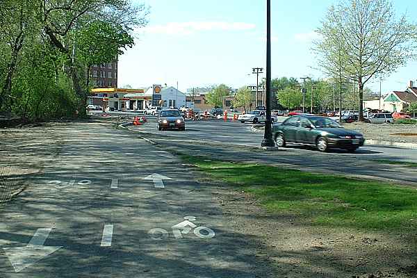
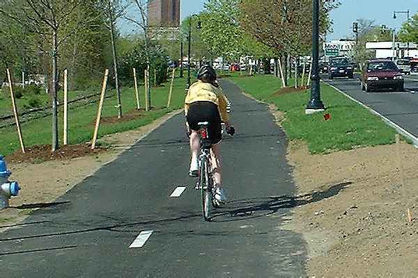
| The path continues along Fresh Pond Parkway (location D on aerial photo). The Parkway's lanes were always narrow, and very few bicyclists ever chose to ride it. The path provides a useful alternative here, at least as far as the Cambridge Waterworks and Kingsley Park. The photo below looks north along the path next to Fresh Pond Parkway. There is a signalized crosswalk at Vassal Lane, north of the Waterworks (traffic signal in upper right of photo). This crosswalk provides the quickest route to many destinations (see dashed, light-blue lines in aerial photo), though it also delays motorists on one of the most heavily traveled commuter routes in the area. This is a location at which the author of this page had suggested an overpass instead. There is a problem here as well with bicyclists' being blinded by motor vehicle headlamps at night. |
Path alongside Fresh Pond Parkway
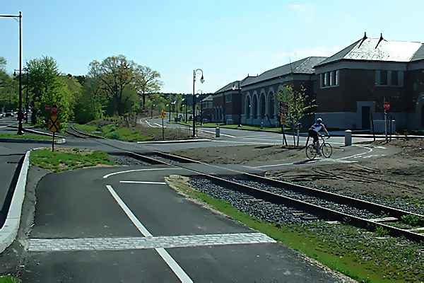
| The path crosses the railroad tracks of the Watertown Branch rail
line (location E in aerial photo). The tight radius of the curve
in the foreground is in violation of AASHTO guidelines; so is the curb directly adjacent
to the path. The pedestrian-type crossing of the two-way entryway to the Waterworks and
Kingsley Park is relatively less hazardous than many bicycle path crossings, as sight
lines are long and there is little cross traffic. The curve here is made necessary by the railroad tracks, which are currently used for shipments to only one business in Watertown. |
Path crosses railroad track and entrance to waterworks
| The next photo (location F in aerial photo) looks back along the roadway in front of the waterworks. Bicyclists do not ride facing oncoming motor traffic in the next lane, because the roadway is one-way in the same direction the bicyclists are traveling. But there is little practical reason for the path to continue this far. The park roadways carry so little traffic that even novice bicyclists would have no problem sharing them. |
Path alongside waterworks
| The path's most serious problems begin as it continues south to Huron Avenue. In the next photo (location G in aerial photo), the end of the path segment in front of the waterworks is visible at the left (reddish pavement). The path enters the one-way bridge over the railroad tracks to Fresh Pond Parkway at an unmarked and undefined crosswalk where motor traffic enters from two different directions. |
View of path at exit from waterworks and
Kingsley Park parking area.
Scroll right if necessary to view the
rest of the picture.
 |
| The next photo shows the bridge from the other end, with Fresh Pond Parkway on the
right. Cyclists are directed to use a two-way bike lane; those traveling north (away from
the camera) are adjacent to oncoming traffic. Two-way bike lanes violate AASHTO
guidelines. The hexagonal marking in the left lower part of the photo appears to be a location for a bollard, as yet not placed, which will further force northbound bicyclists out into oncoming traffic on the bridge. The sidewalk next to the parkway also is odd. There are no destinations along this sidewalk; a sidewalk past the waterworks building would have been much more attractive. But there is none, so pedestrians use the bicycle path. |
Bridge over railroad tracks viewed from other end;
Fresh Pond Parkway on right.
Scroll right if necessary to view the
rest of the picture.
 |
| The path continues as a sidepath along Fresh Pond Parkway. An
attempt is made to separate bicycle and pedestrian traffic on the sidepath by using
different colors of pavement. The path pavement is asphalt and the sidewalk pavement
is concrete, guaranteeing that one will eventually sink relative to the other and the
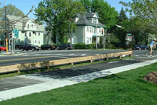
resulting step will snag bicycle tires. The path ends at the northwest corner of the intersection of Fresh Pond Parkway and Huron Avenue (location H on aerial photo). Bike lanes on Huron Avenue start on the east side of this intersection. This is an intersection not to be taken lightly; it carries heavy traffic in every direction. A young woman walking across this intersection with her bicycle was killed by a left-turning truck in early 2002. The intersection here does have an exclusive (four-way) pedestrian signal phase, the only kind that would be practical for bicyclists to get to the eastbound bike lane in one diagonal movement, but no signs indicate this possibility, and right turns on red are allowed -- so the pedestrian phase is not really exclusive. When the author was observing and photographing the path, some the bicyclists turned around and went back when they reached Huron Avenue, some waited for the light, and others ran the light.. The extension of the path beyond the waterworks building is an example of "connect-the-dots" bicycle planning: the obsession that special bicycle facilities must be connected end-to-end. This obsession can result from the idea that a community is connecting a route "system." However, existing streets, perhaps with improvements, often provide shorter and safer routes. "Connect-the-dots" bicycle planning has led to a hazardous crossing and a longer route here. At the Huron Avenue end of the project, getting from the bike path to the bike lane on the corner diagonally opposite requires crossing two sides of the intersection. Fresh Pond Parkway is just as bicycle-unfriendly south of this intersection as north of it. Parallel streets are convenient, and carry lighter traffic. For this reason, the likely movements bicyclists will make at this intersection are to and from Huron Avenue. Travel to the west (right) on Huron Avenue would better have been managed with a path starting from location G in the aerial photo and exiting the park at the T intersection with Aberdeen Street, a block west of Huron Avenue . The path would form a fourth entry to that intersection and could be served by ordinary vehicular traffic signals. A shorter route to the east is provided by the crossing at Vassal Lane and Lakeview Avenue, lightly-traveled streets which connect to Huron Avenue Parkway (dashed light blue lines at right side of aerial photo). |
End of path at Huron Avenue. How are cyclists
supposed to cross to the bike lane on
the diagonally opposite corner? There is an exclusive
four-way pedestrian phase, but it is negated by
legal right turns on red.
Top: Home Page
Up: Table of Contents
Previous: Concord Avenue west of rotaries
Next: Concord Avenue sidepath